Passionate Mother, Grandmother and Motorbike rider and Wife. Bought my husband a Motorbike for his 40th Birthday, and then decided to take up the "reins" myself a couple of years later.
About Sigrid
Passionate Mother, Grandmother and Motorbike rider and Wife. Bought my husband a Motorbike for his 40th Birthday, and then decided to take up the "reins" myself a couple of years later.
Date: 07/08/2017 From/To: Gudvangen – Høyheimsvik Distance: 127 Km Total Distance: 9876 Km Weather: Cold, Drizzling, Cloudy, Sunny Road: Paved
This time we packed up and started in good weather for a change.
The road wound up a mountain site, unfortunately we got stuck behind an Italian camper van, and the diver was not sure how to drive this thing. On one occasion he just stood in the middle of the road and waited for the oncoming car to do something. This was the time when we overtook him just to stop on the next turnout for a picture where he arrived not long after. So we hurried with the picture and took off again just before him.
A couple of hairpins later, we found a great viewing platform, so in this case we parked the bikes properly and took some nice pictures.
The view was just stunning.
From here we continued, this time we didn’t have a camper van in front. In fact, it felt we are the only ones on this scenic road.
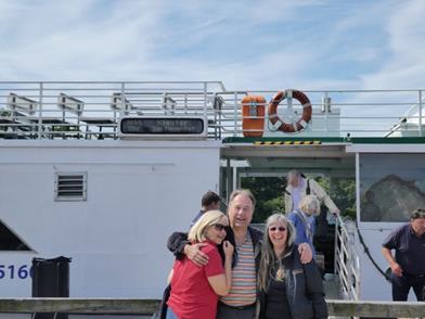
At the end of the scenic road there was a ferry crossing. The weather became again warmer and less cloudy.
So we took the opportunity and had a coffee with nice cake. Unfortunately the earmarked camp ground was full, but the host was really friendly and suggested us another camp ground.
We got a really nice cabine, with a great view onto a waterfall on the opposite side of the lake.
Since the weather forcast was good, we aim toride the ‘Snognefill’ scenic road next.
Date: 02 – 03/08/2017 From/To: Preikestolen Campground – Rjukan Distance: 333 Km Total Distance: 9325 Km Weather: Cold, Drizzling, Cloudy, Sunny Road: Paved
We had breakfast and I could see the black clouds coming in. As you can see, I wasn’t too happy.
It started to rain heavily, so we packed up everything except the tent. When the rain shower stopped and we opened the tent, there was a collection of lakes in front the tent.
We packed up the wet tent and off we went. The rain stopped, started, stopped ….. and then we needed petrol. Well since were prepared, we considert to have lunch outside J. Not long after the break the weather cleared and the rain stopped. We hopped onto a ferry and it started to get warm.
At the end of the day we opted for a cabin on a camp ground.
We unpacked the wet tent and set it up, temporarily. It was dry in no time.
The next day we continued to Rjukan, a small town close to the ‘Rjukan Falls’. The falls don’t ring a bell, but maybe ‘Vemork’ does – The movie “The Heros of Telemark” is based on this location, more to that later. On our way we passed the farm ‘Myllareguten’ the home of the famous Norwegian fiddler ‘Torgeir Augundson’. To be honest, I didn’t know much about him before we passed his stature J
The Vemork hydro power station was built to produce fertiliser and years later to produce ‘heavy water’. This was one possibility to harness nuclear power or to build a atomic bomb. Germany invaded Norway and started to use the heavy water for its research. The allies realised that it would be dangerous if Germany continues with the research and did everything to destroy to ‘Vemork’ hydro power station. There were saboteurs, some bombardments and at the end sinking of the ferry “Hydro” that transported all the heavy water created in the last year or so. This was around 1944 and the end of the German research. So below is the famous hydro power station and the generator house.
And me trying to recitify some things – rumwuschele and of the Knöppsche drücken, dürfen nur mer, de Experden J
Anyway, there was an intriguing example of heavy water. Heavy water (deuterium) ways ~ 10% since it has an additional neutron. This gives deuterium different properties. So here is one litre of water and one litre of deuterium and deuterium is really ~10% heavier. Apparently the human body contains small amonts of deuterium and we can drink it without any problems.
When we left the museum the clouds were just coming in, so we hopped on our bike and rode home, to a nice warm cottage. Tomorrow we will continue on some scenic routes to ‘Geilo’.
Date: 01/08/2017 From/To: Preikestolen Campground Distance: 0 Km Total Distance: 8992 Km Weather: Cold, Sunny Road: Paved
We started really early, just before sunrise.
We arrived at the Preikestolen 30min later, parked the bike and off we went.
The sun just started to rise over the first valley
And after 90 min up and down, Sigrid was puffing and I needed a rest.
Just before the top, we had a great view over the Lysefjord
And here it was, the Preikestolen. We took the typica pictures posing on the rock. This was close enough for me.
This was the view back onto the Lysefjord with sunshine.
I thought I clean up the path and move the rocks laying around.
After the four hour hike, we passed streams of visitors going up. When we arrived at the carpark there were more then 10 tour busses parked. We hopped onto the bike and returned to our campground with private pool in front of the tent.
Date: 31/07 01/08/2017 From/To: Suleskard – Preikestolen Campground Distance: 53 Km Total Distance: 8992 Km Weather: Warm, Sunny, Cold, Rain Road: Paved
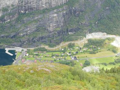
Weather forecast, rain, but with a window of two hours, again… Not sure where the weather forecast put these two hour windows but there is hope…. So at lunch the rain stopped and we set off. And this time we were lucky! Just as we arrived at the Kjerag, just before we descended down to the Lysebotn, the sun came out. Below you can see the town Lysebotn and the port on the left, and on the road on the right.
Below a panorama shot.
After we arrived at the bottom, the clouds came in and it started drizzle. It didn’t take long before the ferry arrived.
On the ferry we could see the Kjeragboltn from the botton, the left show it from the botton, the right a bit zoomed in.
During the one hour trip, we could see our next target, the pulpit rock, it didn’t looked to big from the ferry. Tomorrow should be a day without rain, so we earmarked it for our trek.
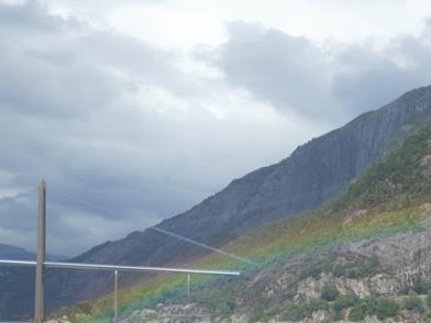
On our way to the destination port, Foresand, we crossed throug a bridge that looked like the golden gate bridge and I got it even with a rainbow.
So we continued to the campground.
Since we would stay for a couple of days we camped. Finding a spot to pitch the tent proofed to be difficult, since most of the lawn was soggy. The right picture shows the camping table (design by Klaus), which did a fabulous job.
Tomorrow we will hike to Purple Rock or Preikestolen. We got some advice from the lady in the office re the best time and she suggested early morning.
Date: 27-28/07/2017 From/To: Oslo – Hjartdal Distance: 179Km Total Distance: 8760 Km Weather: Cold, Raining, Sunny Road: Paved
At the Ulysses club meeting back in Germany we meet a group of Norwegian Ulyssians. I went with them through my travel plans. In general I had already most highlights, except the Stave Church in Heddal. What is a stave church? You might ask:It is a elaborately carved wooden church
This was our goal today. We left Oslo and arrived in Heddal in the afternoon. The Heddal Stave Church is the Norway’s largest stave church.
Doesn’t it look magnificent? Inside but around the main church was a walkway, where the people stored there weapon before entering the church .The doors and pillar had great carvings.
The church had a well a bishops chair, that dated back to the 13th century (picture right). The altar was not as old, but still impressive.
Anyway,we continued and started to have a look for an accomodation. It started to rain heavily so we looked desperatly for a shelter. We stopped at a guest house on the road but no room was free. Nevertheless the host called a friend J, he had a farm nearby and a guest cottage for a good price and it was free. So we continued a couple of km off the main road to his farm, where his wife and daughter showed us the cottage.
It was really cosy, particular when looking outside and watching the clouds coming through.
The next day, the clouds were gone and the sun was shining, what a beautiful view.
Today we will continue close to Lysebotn and see if we can find a nice accommodation there.
Date: 20 – 26/07/2017 From/To: Oslo Distance: 179 Km Total Distance: 8760 Km Weather: Sunny Road: Paved
On our way to the last accommodation we saw an Ikea, so the idea was to have breakfast there. We arrived just before they finished serving breakfast so they strongly encouraged us to take as much as possible-so we did J
Not long after we crossed the border to Norway we found a ‘Museum for Sience and Technology’. Since we had only 200km to our accomodadation, we stoppd an had a good look. Well, there were plenty of sicence experiments, and we tried most of them J
I couldn’t resist to have my picture taken in a space suit J and Sigrid played with the ball liftet by water.
After so much entertainment we decided to continue to the flat we’d booked in Oslo via airbnb. We were a bit skeptical since we had one let down in Sweden. But this time it worked well without a hitch.. The building didn’t look very enticing, but the flat was perfect. It had everthing we needed, was in walking distance to the CBD and we could even watch the bikes from the window.
We stolled along the streets for 10 min then we came to a small place with water fountains, some small water falls and a bar. The atmosphere was really nice and relaxing. The audience were mostly young people and plenty of them were on a push bike.
The next day we walked along the rear to the city center, to get Sigrids mobile phonefixed. It was hard to get charged, the small USB socket must have been damaged when Sigrid lost it. On our way we found some nice art in the street. I like the chandollear hanging in the middel of a foot path.
Or the beer bottle with very strange pictures and text.
We found a shop which would repair the IPhone but it would take an hour or so. So we had a look at Oslo Central Staton
We found the operea house, but it was too late for a guided tour, so we decided to do that tomorrow. The next day we were down there again for the guided tour. On the left is the opera house, which was finished in 2008. On the right is Sigrid on the main stage. We could even see how the main stage was constructed. Each of these squares can be moved around separately , the stage is actually a lift which goes down four stories.
You can walk as well up the roof which we did. You have a really good view on Oslo, you can even see the ‘Holmenkollen Ski Jump’.
From here we walked direction ‘Nobel Peace Center’. We didn’t’ realise that only the ‘Nobel Peace Price’ is awared in Oslo, whereas all other prices are awarded in Sweden. Anyway, on the way we found that nice fountain with a hand sculpture.
And some troll houses on a traffic light J
Finally we arrived at the nobel peace center. There was an exhibition about ‘Juan Manuel Santos’ the colombian presiden who was awarded the 2016 nobel peace price.
And here is the place where the award is given, the Oslo city hall. There are as well guided tours, but we were too late, so some pictures from the outside will do.
Sigrid rolled her angle at the Opera house roof. I must admit, I stumbled as well a couple of time, the sureface is not always even and there are sometimes odd steps which are hard to see if you look around. Anyway, the ankle started to swell, so Sigrid cooled it down.
Below are some pictures from the park leading from our accomodation to the city center.
The next day we had a go at the museums. In Oslo there is something like a museums peninsula housing multiple museums. We opted first for the Vikings and then the Kon-tiki museum. The Viking museum offers a stunning view of three restored longboats from different times. Really interesting was as well where the Vikings travelled between 750 and 1050 AD, particular when you look at the boats and imagine to go on a boat trip from Norway to New Foundland on boats like this, even with multiple stops between.
The boats had some intricate carving.
The Viking had as well carts and slates; both could be disassembled to transport it on a ship. The slate has as well some intricate carvings.
The next stop is the Kon-tiki museum. When I heart the name first, I was thinking straigh away on the Kontiki tours (tour for young people, plenty of partiing).
The Kon-Tiki museum is an exibition showing the live and adventure of ‘Thor Heyerdahl’. He gained worldwide fame when he crossed the Pacific Ocean (Peru to Polynesia) on the balsawood raft Kon-Tiki. The expedition was designed to demonstrate that ancient people could have made long sea voyages, creating contacts between separate cultures
The original raft was exhibited there.
After his success in 1947 he had a go at prooving that the Agypts could have sailed to the Caribian with one of there reed boats. The first attempt failded due to a boat builder design error- the boat just disintegrated during the journey. The type of boat was apparently known in ancient Egypt and still constructed by the Buduma people from Lake Chad. For the second attempt he used the Aymara Indians from Bolivia, which built almost exactly the same type of boat. They must’ve done something different, since the second attempt worked. J
We were realy fascinated by the stories about the planing of the trip, preparation, selection of the crew, building of the vessel and executing the trip. For example: the material for the balsa raft. The balsa trees were not growing close to civilisation anymore, only in the rain forest. But the transportation was deemed as impossible, well Thor and a friend went into the jungle and organizded the wood. He had the same drive to overcome all other obsticles in his way and finally went on the jouney
The next stop was the Frogner Park, where the Vigeland installation can be found. Vigeland was an Norwegian sclupturer and 212 of his bronze and granite sculptures. The center of the installation is the Monolith Plateau, which houses the monolyth itself and lots of granit sculpures around.
On the bridge to the platform, you can see multiple bronze sculptures. On the left, Sigrid tries to at a falling child J and the angry boy, which is better known to the public.
Again a picture of the monolith-it shows more than 100 humans rising toward the sky.
The entry to the plateau had multiple wrought iron gates, each showing human figurines.
That was enough for a day, so we returned to our accommodation. The next day we strolled to the city. On the left hand side you can see the green area in the middle of some houses, which is used by nice weather for people picknick, play ball or just sunbath. We found a building which really looks like a living container.
In the city we found a new definition of ‘Sky diver’ J
The last day, we gave our noble steeds some TLC and cleand them thourourly on the neaby petrol station. As we found out, people use it as well to clean the pushbikes.
Tomorrow we are leaving Oslo and start our Norway trip.
Date: 16 – 19/07/2017 From/To: Abbekås – Oslo Distance: 890 Km Total Distance: 7638 Km Weather: Cold, Drizzling, Sunny Road: Paved
We had a casual breakfast and Sigrid organized some fresh herbs for her to take. We were packing up and said good bye to Gabi, Mathias as well as Bettie and Jürgen.
We reached Rostock just in time for the ferry.
We arrived late in the evening in Malmo and rode to our prebooked accomodation in Sweden. The hostel was build from previous stables.
The next day was nice and sunny, however staying longer was not an option because everything was booked.
So we booked some Airbnb for today and off we went. When we arrived at the address, the house didn’t exist there and nothing similar in the street. We confirmed with some locals that we are at the right street, town, state and countryJ. We tried to contact our host, but she didn’t’ respond. So we started to ride to the next town, there should be some sort of conference centre with a reasonable price, at least that what hotels.com told us. So off we went. We arrived in a town which felt a bit remote. When we arrived at the conference centre, it was closed. Somewhere was a phone number so we called. The manager arrived five minutes later and opened a house for us. The price was really low and we were the only ones in the conference centre. Here we had some nice dinner.
The next day we started to ride around the area and found an old church. We had a look around when the priest approached us.
He explained why the church had two organs and showed us a font where the stone was from 1000BC. It was hard to belief that this peace was more than 1000 years old.
He mentioned as well that the original church was a bit further south and the restored walls were still there.
The old church was close to a lake, so Sigrid couldn’t resist dipping her feet in. Well, it was ‘refreshing’.
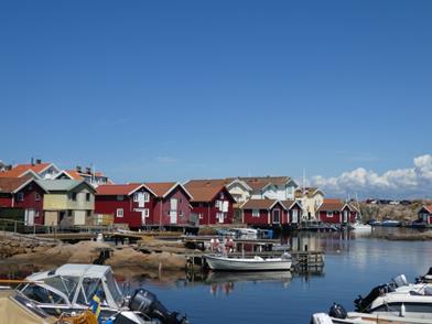
The next day we booked to an accommodation close to the west coast of Sweden. Our previous host suggested to visit ‘Smogens’ it would be a nice fishing village. So we went to Smogens before we went to our accommodation. Below are some pictures.
A bit outside there was a beach with a small pool, mostly setup for small kids. From this pool there was a foot path glued to the rocks J. The water was cristal clear and from the bridge you could watch some fish and yellifish swimming around.
From here we drove to our accomodation. We had some difficulty to find it, since I didn’t read the number on the house correctly. At the end, a lady living in the street, did show me the house J
.
So after we settled in our accomodation, we had a short walk torwards the large bridge in this aresa. Here is the attempt to take a picture of the large bridge,-still looks way smaller than. In reality…
Date: 012 – 15/07/2017
From/To: Copenhagen – Rügen
Distance: 93 Km
Total Distance: 6509 Km
Weather: Cold, Drizzling, Sunny
Road: Paved
After a nice breakfast we left Niklas and went over the impressive Őresund Bridge to Trelleborg, where we boarded the ferry.
The ferry was quite luxerious, we even had power points and free Wifi J. Just before we arrived the sun was setting, the sky with the clouds looked great.
Gabi and Matias picked us up and showed us the way. They had rentet a house and there was one free room earmarked for us! We could not resist..:-).
Next morning we had breakfast and then around 9AM we went to pick up fresh bread. There are a couple of boxes based on an honor system., you take something out and put the money into the box.
With the fresh bread in the trunk, we started our site seening tour. Gabi and Matias had a couple of things in mind. First we stoped at a sort of house boat, which was really a caffee/restaurante where they were selling as well fresh fish. On our way from the carpark to the boat we found a very intreging sign, be aware of “Otter” for the next 1km.
We had a yummy fish breadroll before we continued. The next stop is a nice beach with ‘Strandkörbe’. I’m not sure but I never realised that the ‘Strandkörbe’ are a great invention. You can sit or lay down, have shade or not and you can lock your belongings in a locker under the sea when you have a swim. Anyway, we had a short stroll and some discussion with a local about a possible parking fine if we park in this area. Since we had a very brief visit, we took the risk J
Form here we went to an öco shop on a farm, which sold all kind of products, from bread, nudels and locally produced marmelade
The company logo were gummy boots hanging upside down.
After buying all that food we got hangry, so the next stop was a coffee with a marvellous view. We could watch the ferries passing by a.
The next planned stop was a restaurante, unfortunatelly theye were closed, but when we had a look around I found the nice motor boat, it looked like one of the Stoertebecker boats.
Ok, Gabi did book dinner on a restaurant, overlooking the stage of the ‘Stoertebecker Festspiele’. The location looked expensive, but to our surprise it was quite ok.
Just a sculpture in the entrance area.
Here we celebrated a nice day. In the middle is the Stoertebecker stage, it’s not good visible at this picture.
Here I sumed in, you can see all the people seated ant the stage.
Even more zoom, the setup had as well horses and ships
At the end of the performance there was even a fire work, that we could visit from our table. What a great location.
Gabi and Matias had planned to visit “Hiddensee”, a small Isalnd west of Ruegen. We hopped on a ferry and after an hour we arrived on Hiddensee.
By accident we stumbled across a fishery museum, which had plenty of information how the fisherman were living in this area 100 years ago. Each family had a runen, which was used to determine who had to get out to check if the traps are ok.
From here we walked through an area which was a mixture out of ‘Lüneburger Heide’ and Beach.
When we continued we came across the summer house of Asta Nielsen, a famous German movie star. The house had a unique structure with a round corner on one side. In the house was some documentation about Asta Nielsen life as well as the architect who designed the house.
At the end of our walk we ended up at the harbour, where we hopped on the ferry to get back. Today we planned a BBQ for dinner, so we borrowed the BBQ from the host. The meat from a local butcher was great!
Next morning I heard a strange noise and had a look at the roof, and here they were, two storks ‘Störche’. I haven’t seen them that close.
Today we planned to have a round trip with a steam train, the ‘Rasender Roland’ and then return with a ship.
On the way we came across a strainge houst. Looks like the builder had the plan upside down J.
Next we went to the train station an waited for the steam train. The train has a smaller gauge then the modern trains, so they added an additional rail, so both trains could use the same track. The sun was shining, so we decided to sit in an open carriage.
After the train we walked to the habour, where the ship was waiting.
We found a viking boat there, not sure what the importance of it is, but it looked nice. On the other side, there was a ‘Rowing Ferry’, a guy who rowed the boat from one sie to the other and took some people.
Below is just a house that looked quite iteresting.
During our cruse, we found a small Island with a building on it in the middle of the lake. This was apparently used to de-magnetise ships, but it’s not in use anymore.
After a quick catch up with Reni and her friend Margret in her Feriendomizil Speranza
we followed an invitation of our host for a BBQ. What a delicious BBQ and interesting evening! We talked to the middle of the night.
Tomorrow we would leave Ruegen and would travel to Schweden.
Date: 03/07/2017 From/To: Thorshavn to Kopenhagen Distance: 483 Km Total Distance: 6899 Km Weather: Cold, Drizzling, Sunny Road: Paved
On the ferry we had a beautiful sunset.
And in the morning we got ready for departure.
The reason why we visited Niklas was: He had picked up some paper work for me (German Visa), which is required if I like to stay for more than 3 month in Europa. This paper was send to Klaus, who gave it to Gerlind and Peter, who gave it to Niklas in Zürich, where Niklas had his bachelor graduation -long story… Niklas recommended that we take the ferry, however when we arrived we found out that the ferry wouldn’t leave before the next two hours. So we walked across the ‘Havnen Perle’, which is apparently a famous dinner. I ordered some beacon and egg and Sigrid a sort of fish burger. Both meals were huge and yummy.
The ferry transfer was nice, we went through rain front but when we arrived it was over. We found Niklas accommodation without any problem, took us only a while to find the right door J. Niklas did prepare a lasagne for us, which tasted great. The lasagne with some red was marvellous. We talked for a while before we hopped into Niklas bed, which he kindly freed up for us! He moved into the room of a friend for the night, what a champ!.
In the morning I realised that I could remotly control my camera, so we gave it a try, it worked J
We packed up and left for…. no not Norway, we left for Ruegen, Germany!.
Date: 07-09/07/2017 From/To: Thorshavn Distance: 265 Km Total Distance: 6681Km Weather: Cold, Drizzling, Sunny Road: Paved
In the morning we queued up to get onto the ferry. The weather was exactly when we arrived. Cold and foggy, just miserable.
So we borded the ferry in the morning and arrived in Faroe Island at 2AM, lucky that we had booked accomodation via airbnb in Thorshavn. When we left the ferry , we meet a biycile rider from Western Australia. He was travelling in Iceland before and will now have a look at the Faroe Islands.
When we arrived in the morning, the accomodation was really walking distance from the ferry terminal. So we parked the bikes and went into our accomodation. The host did know that we arrive in the middle of the night and left the key in the door. All worked fine and we had a good sleep. In the morning we tried to find out why our phones were not working, we had some Iceland phone cards which should work all over Europa. After talking to the servant in the local Vodafone shop and making multiple phone calls to the Icelandic Vodafone, it turned out that ‘Faroe Island’ is not part of the EU. So we changed the type of account and everything worked again.
We had a nice walk around Thorshavn. On our way to Iceland, we stopped here and I could see the light house. This time we visited from Land. The light house is located in an old fortress which still had the cannons.
We found some sculptures, looks like people returning from Shopping J
When we passed the habour, we saw some women training for the race on the weekend. What I really liked is they just took their child onto the training session.
On the next day we had another stroll and visited a church we could see from a distance.
On our way we found some nice old buildings and some houses with green roofs.
Then we turned around the corner, and here it was, an Irish pub. So we decided to find out if the Guiness in Faroe Island taste the same as in Australia, well, I think it is a bit more watery.
After we left the pub, the houses had a funny shape J
And the pedestrian path looked rather small. Well, we were actually in the old city, which had really old houses. As you can see, the streets and the houses are quite well preserved.
This was our last day. Today we will board the ferry at 23:00. So we decided to ride to the most north east and most western point of the faroe islands which are reachable without a ferry. Some islands are connected via a bridge, other through tunels and some of them only through a ferry service.
The most north east point was an old church in Vidareidi. Except the church there was not too much to see, just a small village. We had some fog and it started to rain again.
On our way to the west side, we passed a huge church. So we had a look at this as well.
The surprising bit was that a boat was hanging from the ceiling.
And here is a method to oil the chain on the bikes. We just hooked the onto a fishing hook J
After a tunnel with colourfull lights (couldn’t stop to take a picture) we arrived the most western point. It is hard to get the dimension right. The small black dot is ta tunnel exit, and the road down is pretty steep.
Anyway, here we meet Andrew, the Western Australian bicycle rider again. He has done the last steep bit of the road from the last town, including tunnel, which was quite impressive.
We talked for a bit and then returned to Thorshavn. On our way we came across some nice rock formation and a nice church.
Not long after we arrived in Thorshavn the ferry pulled in.
So we boarded around 23:30 and had a beautiful moon rise J
In two day we will be back in Denmark and dash down to Copenhagen to meet with Niklas.


 .
.