Date: 21 – 25/08/2017
From/To: Tromso – Kautokeino
Distance: 546 Km
Total Distance: 12511 Km
Weather: Sunny, Cold, Rain
Road: Paved

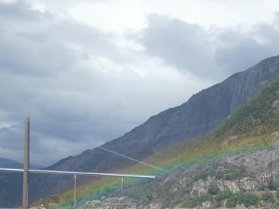
Now the last push to the North Cape was on. Not to push it too hard we would split it in two days. The first day had two ferry rides and it started fine. After the first ferry the clouds came in and it started to drizzle. This continued while waiting for the second ferry. To amuse us we looked around and we found Santa Claus in the woods. On the picture on the right Sigrid holds him in the palm of her hands.


Finally the ferry arrives, it was still drizzling, so we were happy when we could board.

And here are the pictures from the ferry just before we arrive. On the left where we were coming from, on the right were we were going. We were quite happy about the sunshine.

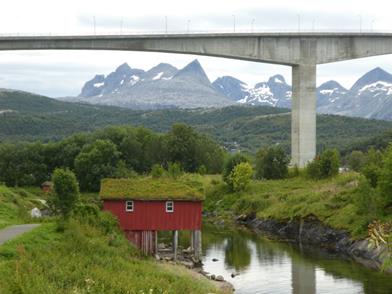
We arrived on our half way mark and got a cabin with a grass roof.


The next day I thought I give our boots some TLC.

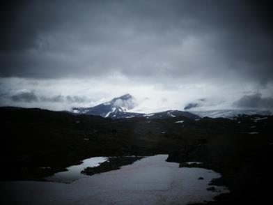
We noticed that the temperature started to drop quite a bit, we were now riding by 8 degrees, which felt much colder when the wind was blowing strong. Below is a picture of a small island on our way.

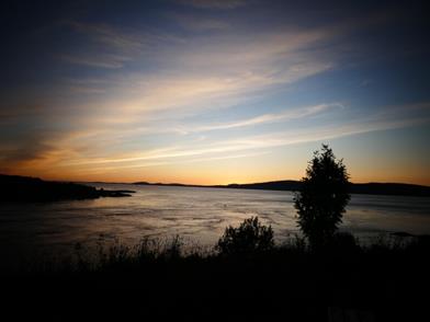
We booked a cabin, that Micha (a friend of ours and a Norwegian travel veteran) suggested. The location was just perfect and so was the sunset.


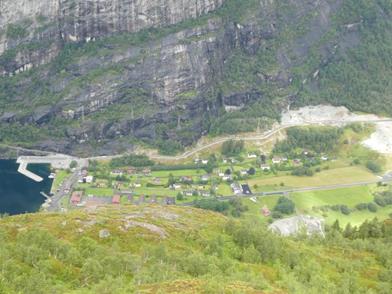
The next day we would walk to the most nothern point of the European mainland, which is not the place with where the globe and the visitor center is. The real point is reachable by a 18km return walk. We thought we do the walk first and then ride to the visitor center and take the mandatory pictures. Here a nice view from a fjord on our way to the car park.

Afer we parked the bikes on the car park, a group of rendears passed bye.


Since it was raining the last couple of days we followed a slippery path J

On our way we meet Jim and Ruth, a Candian couple. We attempted together to find the least muddy path.

And finally we arrived at the most northern point. The point itself is not very impressive, just some grey cement blocks stacked on top of each other. On the right hand you see the view onto the visitor center.


While we enjoyed the view we saw some whales. As usual I had difficulties to take a shot at the right time J

And here just a couple of scenic shots. Sigrid is fetching some water from the creek


The view back to the most northern point and some reindeer walking along.


A big puddle to cross and the road to the visitor center.


And here we are, at the car park of the visitor centre and the mandatory picture of us on the globe.


We made some new friends J

And as a bonus we had a magnificient sunset at the North Cape. We were lucky, the whole day was without rain, just some clouds to set the scene at sunset.


During our ferry rides we met up a couple of times with Oliver. He was travelling in a camper van on the way to Northcape and we met him there at the evening.

What a beautiful day, we made it to the North Cape on a nice day. No strong winds, clouds or rain. So we celebrated with some bubbly at night. The days were still long, but the temperature started to get a bit low so we would make our way south a quickly as possible.

When we packed our bikes the next morning, we got some visitorsJ

On the way we found some fish drying racks, where the fish is hang to dry for some time to preserve it.

When we arrived at our accomodation we looked at the weater forecast and found that it would be quite windy an heavy rain tomorrow, so we decided to stay put for a day. Our host told us that there would be an Sami wedding in the church nearby, and that we should have a look. So we did. Very interesing was the the ceremony was held in two languages, Sami and Norwegian


Here you can see the entrance of the camp ground, there are still some puddles from the last rain.

Date: 11 – 16/08/2017
From/To: Oddvar & Elfrida house – Bodo
Distance: 837 Km
Total Distance: 11385 Km
Weather: Sunny, Cold, Rain
Road: Paved

The next morning we had breakfast and a walk around their house. It is part of a recently house development and is reachable by only one road. Anyway, here is another attempt to use the phone remote control for my camera.


Odvar mentioned as well that just around the corner from their house there is Keikos grave, so we stopped there to have a look. There was even a street sign, that made it easier to find. Keiko was a Orka from the ‘Free Willy’ movie. After a the movie a foundation was founded to set Keiko free again. That wasn’t complely succesful and Keiko died in 2003. A ‘Norwegian’ tradition is to add a stone to the grave, so we did.


We continued torwards the ‘National Tourist Route Kystriksveien’ or the costal highway which goes from Steinkjer to Bodø, is 650 km long and includes six ferries. At the end of the day, we looked for accomodation after the first ferry, since it had rainded again and the weather should become worse for the night and the next day. There we met Leo; a Bulgarian motorcycle rider. We talked and then decided to have a coffee together before he continue.

Than we settled in our accomodation and dried our wet gear.

When we were sitting on the balcony we saw a fox just running around on the camp ground.

So we didn’t move the next day, and this was good choice. The next day was just perfect for riding.

We had to wait for an hour for our second ferry, so we walked around and found a nice exhibion, how people lived in the past here.

This ferry ride would take more than an hour and it would cross the nothern artic circle.

So I got the GPS out to see when we were crossing it. There was no need, since the captain announced it and there was a sculpture on the shore.


The scenery on the ferry was fantastic.


Back on land we passed a a glacier ending in a lake.


At the end of the day we managed to get all five ferries and found some nice accomodation in ‘Saltstrauam’. Saltstrauam is a small straight with one of the strongest tidal currents in the world. The tidal table showed high tight close to sunset, so we walked there and had a look at it. The sunset was funtastic, but we couldn’t se too much from the whirlpool, it was too dark.


The next day we gave it another go. Below are some pictures from the surrounding area.


On the pole is a small light house, which we climbed up to have a better view.


And here is a picture of whirl pool J.


Tomorrow we will hop onto the ferry to the lofoten.

Date: 10/08/2017
From/To: Afarnes – Oddvar & Elfrida house
Distance: 204 Km
Total Distance: 10548 Km
Weather: Sunny, Cold, Heavy Rain
Road: Paved

We started early using a ferry to get to the start of the Atlantic road. The Atlantic road is an 8.3 kilometre long section of County Road 64 and connects small islands by eight bridges—the most prominent being the Storseisundet Bridge. But first we were surprised by the Bolsøy Bridge, which was quite impressive but was not part of the Atlantic road.

We continued to the start of the Atlantic road, when we saw the black clouds coming in. And it didn’t take long before it started to rain heavily. So it became handy when we passed a car park with benches and tables with a grass roof. So we got out our lunch and hot coffee out and stopped for a break.


Well the heavy rain stopped but we could see another cloud band coming in, so we took a short nap before we continued.

And without rain, here it was the Storseisundet Bridge. We were riding this bridge a couple of times to get some nice pictures and movie clips. Cars in the background or in front can be really annoying J. We were really lucky, the whole time no rain.


After we wore out the bridge – back and forth, it was time for a treat, so we went into the fency coffee shop. When we had our coffee, there were these black clouds again L. So we hopped on our bikes and took off.


I would say we were either too slow or too fast, but we got into heavy rain again. We had to use a ferry to get to Oddvar & Elfrida house. We met Oddvar & Elfrida in a hotel in Denmark, the morning when we embarked the Iceland ferry. We talked a bit and they invited us to their house when we would pass through Norway. So we took them up on that offer and contacted them 2 months later and they were happy to meet us. The address was hard to find, so Oddvar picked us up from a carpark with his motorcycle. It was still raining, so we really appreciated it that he picked us up. When we arrived at their house, our boots and gloves were completely soaked.


Elfrida and Ottvar made us feel right at home. The fire was going and It is soo nice to sit dry in a warm house, particularely when its heavily raining outside. Elfrida cooked a typical Norwegian dinner for us, Kippfisk, which is dried and salted cod, very delicious.

We had a great evening talking about Oddvar & Elfrida’s motorcycle adventures and about what it means to live in Norway.

Date: 09/08/2017
From/To: Hornindal – Afarnes
Distance: 242 Km
Total Distance: 10344 Km
Weather: Cold, Cloudy, Sunny
Road: Gravel, Paved

Here is the accommodation on the farm, it looks even better in sunshine.


We started early to ride the Gamle-Strynefjellsvegen, the Dalsnibba, Geiranger and the Tollstiegen. Not a long distance but beautiful roads, partially single lane gravel, partially hairpins up and down. When we came to the first lake, we saw some fog just on the top of the lake. It looked fantastic.


Then we climbed up for the Gamle-Strynefjellsvegen scenic route. The road was partially single lane with hairpins, we were happy that nobody came the other way J. And here we got even more snow close to the road. And this close to the end of summer, imagine what it looks like here in winter.


The next road is the Nibbevegen which leads to the top of the Dalsnibba. When we reached the bottom, the weather looked good, so we decided to pay the toll and climb the road.

Arriving at the top we had sunshine for 5 minutes, then the clouds came in and the view was gone. Sine we had time, we waited for 20 minutes.


The clouds were gone again by this time and we had again a great view. Then we started to decend and stop a the Geiranger view point. Here you can look down the Geiranger fjord. The cruize liner in the background gives a bit of perspective on how high this really is.


Then we decended to Geiranger and climb out the other side. Here you can see the fjord from another direction.


On the side of the view point is a small waterfall running over glas pannels.

When we took a break, we stumbled across the ‘Gudbrandsjuvet’, another waterfall with stunning viewpoints.


And last but not least, we made it to the ‘Trollstiegen’. It took a bit of walking before we got this shot below, but it was worth it.

This was really an amazing day. I think that was the day with the most scenic views so far. Tomorrow we have another highlight, the ‘Atlantic Road’.

Date: 08/08/2017
From/To: Høyheimsvik – Hornindal
Distance: 353 Km
Total Distance: 10102 Km
Weather: Cold, Drizzling, Cloudy, Sunny
Road: Paved

Today we planned to ride the ‘Snognefjell’ scenic route. I was hoping to have still some snow laying around, but not too muchJ. So we started early in the morning, had beautiful weather, some clouds hanging in the mountains.


And then we went up, and up, and there was really still some snow around. On the right picutre you can see the road coming up.


Our first stop was at a prisma showing where particular mountains are. You line up a name with the two glass panels and the look down on them and you see the mountain. Well, most of the mountain peaks where hiding in clouds.

The mountains around were amazing and so are the roads. The road on the left was an exception, most of the time there were some nice twisty roads. But here I found still some snow close to the road.


There was another view point with a square granit picture frame J. The snow peaks at the back are the highest glaciers in Norway, there is skyseason the whole year.


On our way down we met a familiar number plate, a car from Tasmania. So we met Fritz and Ursula, we talked about their travel and how they got the car to Europa. Anyway, they suggested a nice bakery in the next town. Apparently people from the entire surrounding would buy from there. So we decided to check itout.

So we did, the shop was easy to locate, look for the longest queue outside of a shop. So we bought some bread and some desert and had a coffee. And we meet Fritz and Ursurla again. We had a nice long break before we departed and were headding to Geiranger. I had the idea that we could camp there for a couple of days and do tours from there.


Well, after we decended to Geiranger in a throng of tour busses, caravans and cars , arriving at the campground, we learned that there were no cabins left and only 1 camp site (I would say it was only one half of a camp side as crowded as it looked). There is a second campground in Geiranger, on the opposite site. Seeing no reason why this campground should have cabins or camp sites left I saw the ferry comming in-And in a quick decision we opted to get ‘outathere’. We took the ferry to Hellesylt, which was on our to do list anyway. The evening was nice and we had a great trip throught the fjord. A cruizeliner was leaving as well, and when he turned we saw all of the sudden a rainbow. What a wunderfull view.


When we arrived in Hellesylt, there was a small waterfall just ouside of the ferry stop. We took some pictures before we hurried to get going as we saw some dark clouds coming torwards us.

So we hopped onto the bikes, and got caught in the rain L but shortly after Sigrid found a great accommodation on the way, a nice cabin on a farm.

Date: 07/08/2017
From/To: Gudvangen – Høyheimsvik
Distance: 127 Km
Total Distance: 9876 Km
Weather: Cold, Drizzling, Cloudy, Sunny
Road: Paved

This time we packed up and started in good weather for a change.

The road wound up a mountain site, unfortunately we got stuck behind an Italian camper van, and the diver was not sure how to drive this thing. On one occasion he just stood in the middle of the road and waited for the oncoming car to do something. This was the time when we overtook him just to stop on the next turnout for a picture where he arrived not long after. So we hurried with the picture and took off again just before him.


A couple of hairpins later, we found a great viewing platform, so in this case we parked the bikes properly and took some nice pictures.


The view was just stunning.

From here we continued, this time we didn’t have a camper van in front. In fact, it felt we are the only ones on this scenic road.


At the end of the scenic road there was a ferry crossing. The weather became again warmer and less cloudy.

So we took the opportunity and had a coffee with nice cake. Unfortunately the earmarked camp ground was full, but the host was really friendly and suggested us another camp ground.

We got a really nice cabine, with a great view onto a waterfall on the opposite side of the lake.

Since the weather forcast was good, we aim toride the ‘Snognefill’ scenic road next.

Date: 02 – 03/08/2017
From/To: Preikestolen Campground – Rjukan
Distance: 333 Km
Total Distance: 9325 Km
Weather: Cold, Drizzling, Cloudy, Sunny
Road: Paved

We had breakfast and I could see the black clouds coming in. As you can see, I wasn’t too happy.


It started to rain heavily, so we packed up everything except the tent. When the rain shower stopped and we opened the tent, there was a collection of lakes in front the tent.


We packed up the wet tent and off we went. The rain stopped, started, stopped ….. and then we needed petrol. Well since were prepared, we considert to have lunch outside J. Not long after the break the weather cleared and the rain stopped. We hopped onto a ferry and it started to get warm.


At the end of the day we opted for a cabin on a camp ground.


We unpacked the wet tent and set it up, temporarily. It was dry in no time.

The next day we continued to Rjukan, a small town close to the ‘Rjukan Falls’. The falls don’t ring a bell, but maybe ‘Vemork’ does – The movie “The Heros of Telemark” is based on this location, more to that later. On our way we passed the farm ‘Myllareguten’ the home of the famous Norwegian fiddler ‘Torgeir Augundson’. To be honest, I didn’t know much about him before we passed his stature J

The Vemork hydro power station was built to produce fertiliser and years later to produce ‘heavy water’. This was one possibility to harness nuclear power or to build a atomic bomb. Germany invaded Norway and started to use the heavy water for its research. The allies realised that it would be dangerous if Germany continues with the research and did everything to destroy to ‘Vemork’ hydro power station. There were saboteurs, some bombardments and at the end sinking of the ferry “Hydro” that transported all the heavy water created in the last year or so. This was around 1944 and the end of the German research. So below is the famous hydro power station and the generator house.


And me trying to recitify some things – rumwuschele and of the Knöppsche drücken, dürfen nur mer, de Experden J

Anyway, there was an intriguing example of heavy water. Heavy water (deuterium) ways ~ 10% since it has an additional neutron. This gives deuterium different properties. So here is one litre of water and one litre of deuterium and deuterium is really ~10% heavier. Apparently the human body contains small amonts of deuterium and we can drink it without any problems.

When we left the museum the clouds were just coming in, so we hopped on our bike and rode home, to a nice warm cottage. Tomorrow we will continue on some scenic routes to ‘Geilo’.

Date: 01/08/2017
From/To: Preikestolen Campground
Distance: 0 Km
Total Distance: 8992 Km
Weather: Cold, Sunny
Road: Paved

We started really early, just before sunrise.

We arrived at the Preikestolen 30min later, parked the bike and off we went.


The sun just started to rise over the first valley

And after 90 min up and down, Sigrid was puffing and I needed a rest.


Just before the top, we had a great view over the Lysefjord


And here it was, the Preikestolen. We took the typica pictures posing on the rock. This was close enough for me.


This was the view back onto the Lysefjord with sunshine.

I thought I clean up the path and move the rocks laying around.

After the four hour hike, we passed streams of visitors going up. When we arrived at the carpark there were more then 10 tour busses parked. We hopped onto the bike and returned to our campground with private pool in front of the tent.

Date: 31/07 01/08/2017
From/To: Suleskard – Preikestolen Campground
Distance: 53 Km
Total Distance: 8992 Km
Weather: Warm, Sunny, Cold, Rain
Road: Paved

Weather forecast, rain, but with a window of two hours, again… Not sure where the weather forecast put these two hour windows but there is hope…. So at lunch the rain stopped and we set off. And this time we were lucky! Just as we arrived at the Kjerag, just before we descended down to the Lysebotn, the sun came out. Below you can see the town Lysebotn and the port on the left, and on the road on the right.


Below a panorama shot.

After we arrived at the bottom, the clouds came in and it started drizzle. It didn’t take long before the ferry arrived.


On the ferry we could see the Kjeragboltn from the botton, the left show it from the botton, the right a bit zoomed in.


During the one hour trip, we could see our next target, the pulpit rock, it didn’t looked to big from the ferry. Tomorrow should be a day without rain, so we earmarked it for our trek.


On our way to the destination port, Foresand, we crossed throug a bridge that looked like the golden gate bridge and I got it even with a rainbow.


So we continued to the campground.

Since we would stay for a couple of days we camped. Finding a spot to pitch the tent proofed to be difficult, since most of the lawn was soggy. The right picture shows the camping table (design by Klaus), which did a fabulous job.


Tomorrow we will hike to Purple Rock or Preikestolen. We got some advice from the lady in the office re the best time and she suggested early morning.

Date: 29-30/07/2017
From/To: Hjartdal – Suleskard
Distance: 232Km
Total Distance: 8939 Km
Weather: Cold, Drizzling, Sunny
Road: Paved

Next morning we started at beautiful sunshine, and then it started raining, hailing


and then sunshine again. We stopped and put our gear into the sun to dry off. Close to Lysebotn we found a campground with nice cabins, so we booked one for the next couple of days. On the right hand side you can see the houses around with green roofs.


The next day we looked at the weather forecast, it was raining for the next couple of days, but there was that tiny window tomorrow from around 6 to..8PM. We were sitting put for the morning and in the afternnon the weatherforecast was still the same. So we arrived at the beginning of the hike around 4PM. The hike consists of three inclines, all of them have some chains to get up or even more, to get down again.


The weather forecast got some points right, the rain stopped for some time, but not completely. And then there were the clouds coming in.

When we climbed up, we were over the clouds.


And then after three hours we reached a ravine where we had to climb through. I wasn’t sure if we were on the right track, but all of the sudden I could see the Keragbolten. The rain has stopped, but the clouds came in and did not leave.

Well, Sigrid looked first how to get to the bolten, then here she was, on the bolten, arms wide spread out.


So now I had a look at the bolten, first from the top. On the right picture you can see me peaking down onto the bolten, and that’s it. I chickened out, no way that I hop onto this bolten. So the picture on the right was as close as I got.

Here are the pictures of the bolten in good weather. On the right picture you can see how to get onto the bolten, taken by other people.


Anyway, on our way back the clouds came in even more and made it impossible to find the way markers…-scaring Sigrid a little.


But at the end we made it and Sigrid was releaved…-me too… On the right picture you can see the car park with our motorcycles; by then the clouds had disapered.


Here we back at the bike. It was 10PM, just before sunset.

A short video can be found here.

We went home and dried our boots with this cool shoe dryer in the hallway. I guess the Norwegians know why they have these dryers in most of the hutts in this area J


The next day the forcast was rain from the morning to the evening, with a couple of minutes break between. Advantage?! We could see a beautiful rainbow straight out of our window.. while we stayed inside, recovering..;-)

Tomorrow we will go down to the Lysebotn, the town at the botten of the lysefjord. A nice windy road, hopefully it stopps raining.